
Your venue's map. Alive, in your brand, on your site.
A precise, interactive map of the whole property — every ride, trail, cabin, and acre. Guests walk it in 3D before they arrive, staff work from the same record, and it is re-flown on your schedule — always current to a flight with a date on it. Hosted by us, branded as yours, embedded on your own domain.
Based in Dripping Springs · serving Central Texas
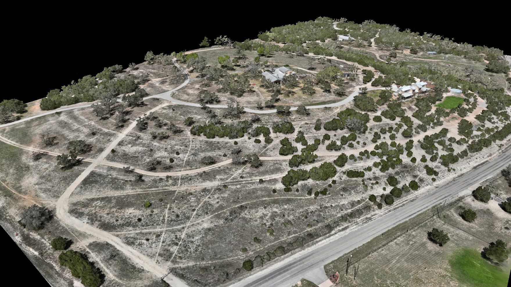
The gate, the front desk, and the job walk
Large parks, guest ranches and resorts, attractions, campuses, and event venues — properties big enough that the map has to work in three places at once. These are the moments it is built for, and each one names a real artifact, not a feature on a roadmap.
The guest at the gate with no bars
The far corners of a big property are exactly where coverage dies. The offline Field Pack puts your own imagery and your own named points on a guest's phone before they leave the lodge — it opens with no signal and nothing expires.
The front desk, handing over a Route Card
Each trail as a printed card — your own imagery with the route drawn, every stop numbered in order, and the flight it was drawn on named on the page. The desk hands a guest a page, not a verbal guess.
The ops manager briefing a contractor
The Handover Pack binds the cover sheet, the Property Key, and every route card into one PDF — every page pinned to the same flight, so the contractor is working from the same map the public sees, not a marked-up printout of a different year.
Your brand on the frame, your words on every pin
A venue map that reads as ours would be a banner ad on your property. This one reads as yours, and that is built in — not promised.
White-label brand kit
Your logo, your colors, on the viewer and every embed — and the embed lives on your own domain, inside your own pages. Styling changes are drafted, previewed against the live portal, and published in one click; guests never see a half-finished look.
Your words on every pin
The map draws from a fixed vocabulary of 58 waypoint kinds — a park picks from a set that runs from restrooms, trailheads, shelters, and parking to emergency access and AED — and every kind can be relabeled in your words, across the property or per project. If your guests know it as a comfort station, the pin says comfort station. We never invent a name for your property.
One map for guests, another for staff
Curate what the public map carries: hide whole categories — the well heads, the service gates, the pump house — from the guest view while your working view keeps everything. That curation is a display choice, and we say so plainly: anything that must stay genuinely private stays off the public map entirely.
The map a guest actually opens
Not a PDF trail map from three seasons ago — the property itself, explorable from the booking page, and still working where the signal quits.
360 walkthroughs at named places
Ground-level 360° panoramas pinned to the map at the places you name — the ceremony site, the trailhead, the midway — so a guest stands there before they arrive.
Narrated trails
An authored route the map flies for the viewer: it pauses where you tell it to, holds each stop as long as you set, and frames each view the way you framed it. Rides in every 3D view of the property. On a campus, this is a self-guided tour — your stops, your words, walked by every visitor who can't make a Tuesday at 2pm.
The offline Field Pack
One file, loaded on a phone, that carries your imagery and your named points into the corners with zero bars. Guests and staff carry the property, not a signal.
The printed Property Key
A numbered legend of every gate, crossing, cabin, and named place — each with its own pictogram, each in your words — for the gate booth, the office wall, and the welcome packet.
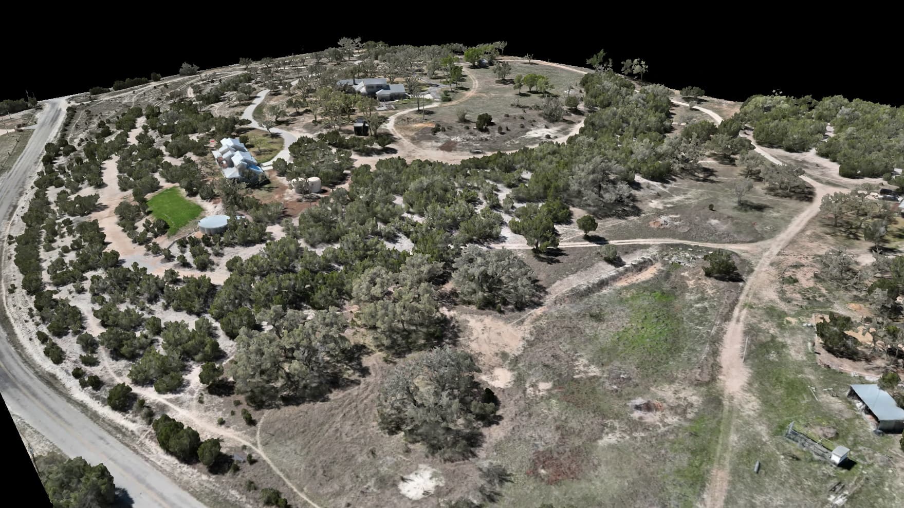
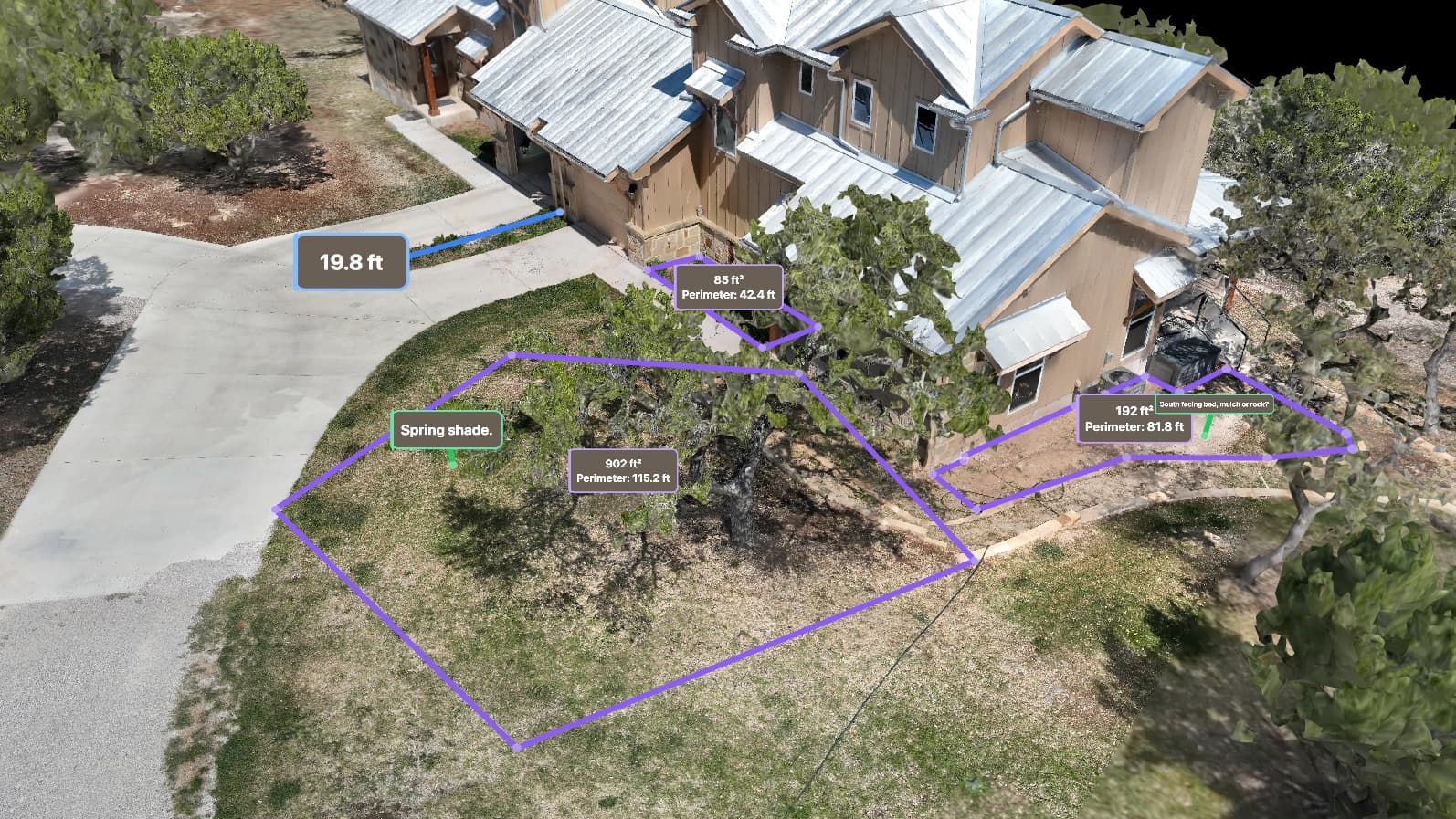
The same flight, working for your crews
Marketing gets the beauty shot; operations gets the numbers. Both come off the same flight, so there is exactly one version of the property and everyone is standing on it.
Measured everything
Distances, areas, and elevations read straight off a dated flight — accurate to about a centimeter. When memory, the old paper map, and the ground disagree, the flight is the record.
Change callouts, named by your landmarks
After every re-fly: what moved, located in your words — “40 m northeast of the hay barn,” not a coordinate. Written from the same named points the guest map uses.
The Handover Pack
The bound PDF a contractor, appraiser, or inspector works from — assembled so every page provably comes from one flight. No mixed vintages, no stale sheet in the middle.
Exports for the tools you already use
GeoTIFF and COG for GIS, LAS/LAZ for the engineers, DXF contours for CAD, KMZ for everything else. Your consultants open your property in their own software — no viewer required.
We measure. You rate.
A venue map is full of judgment calls, and the most important thing about this one is which of them we refuse to make.
Printed by us — measured
We print what we measured and the window we measured it over. The Grade Sheet states each leg's grade as a number, the elevation surface it was read off and the flight it came from; a distance on the map is a distance off a dated flight. Descriptive, checkable, and never dressed up as a judgment.
Entered by you — rated
Ratings are yours: your difficulty scale, your green circle, your names, your call. They enter the map through the same label system that puts your words on every pin — so a rating on your map is always something your operation said, never something we invented.
Capture days, then a map current to a dated flight
This is a hosted product, not a one-off deliverable. We fly the property, build the full map, and keep it online in your brand — then re-fly on the schedule your calendar sets. Seasonal venues re-fly per season; event grounds re-fly ahead of the big dates on the calendar; every re-fly ships change callouts named by your own landmarks. The map is always current to a dated flight, and it says which one.
Three promises ride on every engagement, printed from one catalog so the words cannot drift — here and in the owner's guides:
NO COMPETITORS ON YOUR MAP
Your map shows your property, your assets and your branding. Nothing else — no advertised businesses, no third-party listings, no labels for the place next door.
We can promise it because every layer ON your map is one we made for you — your own capture, your named places, your routes. Where the frame runs past your own ground, what fills it is plain satellite imagery from a third party, credited on the map and carrying no labels, listings or business pins of its own. Printed pages and exported figures go further still: those are composited from your capture alone.
FLAT PRICING, NO PER-VIEW BILLING EVER
You pay for the flight and for hosting, at a price agreed up front. You are never billed by the map load, so a busy season on your website costs exactly what a quiet one does.
Sharing your map widely is the point of having one. A bill that grows every time a guest opens it would be a bill for succeeding, so we do not write one.
OFFLINE AND BUNDLED USE PERMITTED
Download your files and put them wherever you need them — a visitor-centre kiosk, a laptop in a truck, an SD card in a ranger's pocket. They open with no signal and nothing expires.
You own the deliverables outright once the project is paid, so preloading them, bundling them into your own app and handing them to your own people are all just uses of your own property.
What you walk away with
Files on your own drive, at full resolution — not a login that expires. Your scope decides which of these your project includes.
Full-resolution aerial map GeoTIFF (COG)
The whole property as one sharp, flat, correctly-placed image at 1–3 cm per pixel.
Point cloud COPC LAZ · LAZ · LAS · PLY
Millions of measured points — and, on LiDAR scans, the bare ground under tree cover.
Photoreal 3D model GLB · OBJ
The textured model of the property you spin and fly around in the viewer.
CAD & GIS vectors DXF · SHP · GeoJSON
Contours and mapped features as drawing and GIS layers, not pictures of layers.
Measurement tables CSV (Acreage Table)
The figures behind a mapped layer as a spreadsheet, one row per feature, with the units named in the file.
Google Earth overlays KMZ · KML
Your map and layers packaged for Google Earth.
Tile archive ZIP
The streaming tiles behind the online viewer, packaged as files.
Reports PDF
The written record for the flight — what was captured, when, and how it checks out.
What you may do with it
Ownership of the deliverables is assigned to you on full payment. These all follow from that.
You own what we deliver
Once the project is paid in full, the maps, models, point clouds and exports are assigned to you — not licensed to you, not rented.
Use it however your business needs
Copy it, change it, hand it to your engineer, build something new on top of it. There is no permitted-use list to check first.
Print as many as you want
Put it in the offering memorandum, the permit packet, the board deck and a four-foot print for the lobby. Nobody is counting exports.
Digitize it for commercial work
Trace it into CAD or GIS and bill the work. What your engineer draws on top of your imagery is yours as well.
Use it to improve your other data
Align older imagery to it, colour-match against it, use it as the reference the next flight is checked against.
Train models on it
Count cattle, trees, pallets or parking spaces with whatever model you like. They are your pixels to learn from.
Take it offline and hand it out
Load it on a kiosk, a laptop or an SD card and open it in a canyon with no signal. Nothing has to phone home, and nothing expires.
A venue engagement starts as a conversation, not a form — the capture windows, the airspace, and the re-fly calendar are worth talking through. The guided wizard is there for the smaller end.
One real property, in its own brand
The live demo is not a venue — it is a working ranch, our own showcase property, running in its own brand on the exact engine this page describes. What you are evaluating there is the engine: the viewers, the pins, the trails, the printed artifacts. Yours gets your brand, your words, your property.
Put your whole property on one living map
Tell us about the venue — the acreage, the season, what guests ask at the desk — and we'll walk you through what the map would carry and how the re-fly calendar would run.
What this map is — and isn't
A route on this page is a path recorded over this property from our own mapping — a line to walk or fly, and nothing more. It is not a road, an easement, or a right of way, and it is not a statement that the ground it crosses is maintained, legally accessible, or safe to travel on foot or by vehicle. Conditions on the ground govern: check them before relying on a route.
This data is not a legal survey. Embry Solutions LLC does not perform land surveys. For boundary, subdivision, or title surveys, please consult a licensed Texas surveyor.